 English
 Türkçe
 Français
 Deutsch

Bıçak Law Firm has adopted the Equal Earth projection as its preferred choice for general-purpose world maps used in institutional communications. The decision reflects the Firm’s identity as a “Global Law Firm based in Türkiye” and its commitment to proportional accuracy, equitable representation and a genuinely global perspective. The Equal Earth projection, developed in 2018, preserves the relative surface areas of countries and continents while providing a balanced and recognisable representation of the world. Unlike the widely used Mercator projection, it avoids the severe enlargement of higher-latitude regions that can create misleading impressions of the relative size of Africa and other regions. The Firm’s decision follows the UN General Assembly’s September 2026 “Correct the Map” initiative encouraging more accurate and equitable cartographic representation through equal-area projections. Equal Earth is not considered a perfect or universally appropriate map, as every flat projection necessarily involves some form of distortion. The policy therefore applies primarily to general-purpose world maps and does not affect the Firm’s treatment of sovereignty, international boundaries, disputed territories or maritime delimitation, which remain governed by applicable law and authoritative sources. For Bıçak Law Firm, adopting Equal Earth represents a conscious institutional choice to ensure that its visual language reflects the same balanced and international perspective that guides its cross-border legal practice.
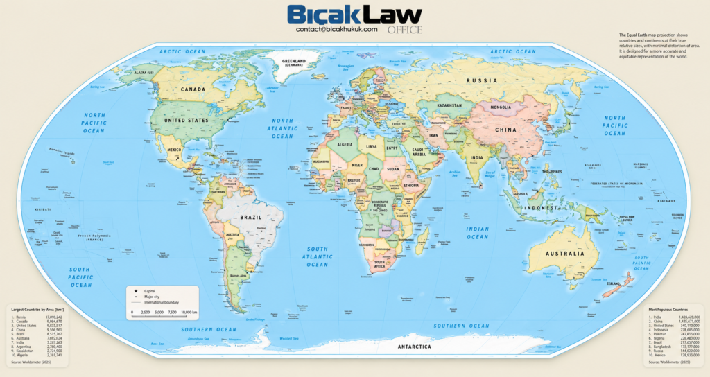
A Cartographic Policy for a Global Law Firm Based in Türkiye
1. The Map a Global Law Firm Chooses Matters
A world map is more than a background image. It is a visual statement about how we understand geography, scale and the relationship between different parts of the world. For a law firm whose work crosses borders, the choice of a world map therefore deserves more attention than it might initially appear to require. Maps feature on websites, in presentations and reports, in international practice materials, country-focused publications and professional communications. Repeated over time, they influence how audiences perceive the relative place of countries, continents and regions within the world. Bıçak Law Firm has therefore decided to prefer the Equal Earth projection for general-purpose world maps used in its institutional communications. This is a practical cartographic policy founded on proportional accuracy, appropriate representation and our understanding of what it means to be a Global Law Firm based in Türkiye.
2. A Global Law Firm Based in Trkiye
Bıçak Law Firm is rooted in Türkiye while maintaining an international outlook across its areas of practice, professional relationships and publications. Our geographical base matters. It shapes our experience and places us at a strategic point connecting Europe, Asia, the Middle East, Africa and wider international markets. Being global, however, requires more than conducting cross-border work. It also requires us to consider whether familiar ways of representing the world remain appropriate for the purposes for which we use them. Maps form part of that visual perspective. For us, the principle is straightforward: Being based in Turkey defines where we are. It does not limit how we see the world.
3. The UN’s 2026 “Correct the Map” Resolution
The immediate occasion for reviewing our cartographic policy was an important development at the United Nations. On 4 September 2026, the United Nations General Assembly adopted the African-led resolution entitled “Correct the Map: Rebalancing Global Cartographic Representation and Promoting Equitable Representation of the World’s Regions, Particularly Africa”. The text had been submitted as draft resolution A/80/L.104, with Togo leading the initiative on behalf of the African Group. The resolution was adopted by an overwhelming majority: 164 States voted in favour, one voted against and six abstained.
Importantly, the resolution does not establish Equal Earth as the single mandatory world map of the United Nations, nor does it prohibit the Mercator projection. Rather, it promotes more accurate and equitable cartographic representation and encourages greater use of equal-area projections, including Equal Earth, particularly where the relative size of countries and continents matters. The distinction is important. The UN has not declared that there is now only one correct map of the world. It has encouraged institutions to reconsider whether familiar projections remain suitable for general geographical representation.
4. What Is Wrong with Using Mercator as a General World Map?
The Mercator projection, introduced by Gerardus Mercator in 1569, was a remarkable cartographic achievement. Its great strength was navigational: it preserves angles locally and enables a course of constant compass bearing to be represented as a straight line. The problem is therefore not that Mercator is simply a “wrong” map. The problem arises when a projection developed for particular navigational purposes becomes a familiar general-purpose representation of the world.
Projecting the curved surface of the Earth onto a flat plane necessarily involves distortion. Under Mercator, area distortion increases dramatically towards the poles. Countries and territories at higher latitudes consequently appear disproportionately large compared with those nearer the Equator. Navigation and proportional geographical representation are different purposes. A projection exceptionally useful for the first is not necessarily appropriate for the second.
5. Africa Is Not the Size We Have Become Accustomed to Seeing
Africa provides the clearest illustration. On familiar Mercator maps, Greenland can appear comparable in size to Africa. In geographical reality, Africa is approximately 14 times larger than Greenland. The effect extends beyond this striking comparison. Higher-latitude regions are visually enlarged, while Africa and other regions closer to the Equator occupy a smaller share of the map than their actual surface area warrants. This matters because maps become mental models. Repeated exposure to a particular projection can influence our intuitive understanding of the relative geographical scale of continents and countries. The issue is not whether accurate measurements are available. They plainly are. The question is whether a general-purpose world map should communicate a substantially different visual impression when effective alternatives are available.
6. What Is the Equal Earth Projection?
The Equal Earth map projection was developed by cartographers Bojan Šavrič, Tom Patterson and Bernhard Jenny and introduced in 2018. It is an equal-area pseudocylindrical projection specifically designed for world maps. Its visual appearance was inspired by the widely used Robinson projection, but it differs from Robinson in one fundamental respect: Equal Earth preserves the relative size of areas. If one geographical area has twice the surface area of another, it occupies twice the area on an Equal Earth map. At the same time, the projection was designed to present continental outlines in a recognisable, visually balanced form. This combination makes Equal Earth particularly suitable for general-purpose maps intended to communicate the relative geographical scale of the world’s regions.
7. Equal Earth Is Not a “Perfect Map”
Our decision should not be misunderstood as a claim that Equal Earth provides a distortion-free representation of the planet. No flat world map can simultaneously preserve area, shape, distance, direction and scale everywhere. Every map projection involves choices about which geographical properties should be preserved and which distortions are acceptable for the intended purpose. Equal Earth prioritises area equivalence. Shapes and other properties necessarily undergo some distortion. That makes it particularly appropriate when the purpose is to show the world as a whole and enable meaningful visual comparison of countries and continents. It does not make Equal Earth the correct projection for every cartographic task. That distinction is central to Bıçak Law Firm’s policy.
8. Accuracy, Equality and Representation
Our preference for Equal Earth rests on three related considerations. First is proportional accuracy. Where a world map communicates the relative physical scale of different regions, preserving their relative surface areas is a rational priority. Second is equitable representation. A general world map need not unnecessarily magnify some regions and diminish others when an effective equal-area alternative exists. Third is fitness for purpose. Maps should be selected according to what they are intended to communicate, rather than solely because a particular projection has historically become familiar. These considerations allow us to support better cartographic representation without treating a technical question as though it admitted only one universal solution.
9. The Legal Meaning of the UN Resolution
The UN development must also be understood accurately as a matter of international law. The General Assembly resolution is not legally binding in the manner of a treaty obligation and does not compel States, businesses, schools or other institutions to abandon Mercator or adopt Equal Earth. Its significance is principally normative, educational and institutional. It encourages reconsideration of established cartographic practices and gives substantial international visibility to the use of equal-area representations where relative geographical size matters. Its practical influence may therefore extend beyond its formal legal effect, particularly in education, public communication, institutional design, publishing and digital technology. For Bıçak Law Firm, the resolution is not the source of a legal obligation to change maps. It is an important international development that prompted us to examine our own institutional practice and make an independent choice.
10. Changing the Projection Does Not Change Borders
For a law firm, another distinction is indispensable. A map projection determines how the curved surface of the Earth is represented on a flat plane. It does not determine where international boundaries legally lie. Changing from Mercator to Equal Earth therefore says nothing, by itself, about sovereignty, territorial status, recognition of States, disputed territories, maritime boundaries or competing territorial claims. This distinction was expressly emphasised by the European Union and its Member States in their explanation concerning the UN resolution. They underlined that the initiative concerns cartographic representation, geographical literacy and the relative size of continental landmasses—not sovereignty, territorial status, delimitation or internationally recognised borders. Equal-area representation and territorial recognition are separate questions.
11. Why This Matters for International Legal Practice
International lawyers routinely work across geographical boundaries. International trade, sanctions and export controls, arbitration, cross-border investigations, migration, foreign investment, shipping, aviation, defence, diplomatic representation and transnational litigation all require lawyers to understand relationships between jurisdictions rather than view countries in isolation. A world map cannot determine legal analysis. It can, however, reflect the institutional perspective of the organisation using it. For a globally oriented law firm, a general-purpose map that represents Africa, Latin America, Asia, Europe and other regions according to their proportional geographical scale is consistent with an international practice that approaches jurisdictions according to their actual relevance rather than inherited visual assumptions.
12. Bıçak Law Firm’s Equal Earth Map Policy
Accordingly, Bıçak Law Firm adopts the following institutional policy: Bıçak Law Firm will prefer the Equal Earth projection for general-purpose world maps used on its website and in its publications, presentations and institutional communications where the purpose is to represent the world as a whole or to compare countries, continents or regions geographically. This preference reflects our commitment to proportional accuracy, global perspective and equitable visibility of the world’s regions. It is a purpose-based preference, not an absolute rule governing every map the Firm may use.
13. Where the Policy Will Apply
The policy will guide the future selection and creation of general world-map imagery across Bıçak Law Firm’s digital and institutional materials. This includes website graphics, international practice-area illustrations, country and regional materials, reports, presentations, training materials, professional publications and social-media communications in which a world map serves a general representational purpose. Existing materials may be reviewed and updated progressively where appropriate. The policy does not require indiscriminate replacement of every historical graphic.
14. Where Different Maps May Still Be Appropriate
Different purposes require different cartographic solutions. Navigation, street mapping, interactive digital maps, specialist GIS applications, transport routes and particular technical analyses may legitimately require Mercator, Web Mercator or another projection. Similarly, a legal matter concerning a particular property, international boundary, maritime zone or territorial dispute may require specialised official or evidentiary mapping rather than Equal Earth. Our governing principle is therefore not “Equal Earth everywhere”. It is the appropriate map for the appropriate purpose.
15. Borders, Disputed Territories and Legal Neutrality
Particular care will continue to be exercised where maps depict politically or legally sensitive boundaries. The Firm’s adoption of Equal Earth concerns projection, not territorial attribution. Where sovereignty, recognition, disputed territories, international boundaries, exclusive economic zones or maritime delimitation are relevant, Bıçak Law Firm will rely on authoritative legal and cartographic sources appropriate to the particular context. Where necessary, maps may also carry explanatory disclaimers. No choice of general-purpose map projection should be interpreted as expressing a legal position concerning a territorial dispute.
16. Türkiye at the Centre of Connections, Not the Centre of the Map
Türkiye occupies an exceptional geographical position between regions, markets and legal systems. That location is central to Bıçak Law Firm’s identity and international practice. But there is an important distinction between being based somewhere and placing that location at the conceptual centre of the world. Our international perspective does not require Africa, Asia, Latin America or any other region to appear disproportionately small in order for the geography familiar to us to appear larger. Turkey is important to our identity because it is where we are based and from where we connect with the world – not because our map needs to make our part of the world visually dominant. That is precisely what we mean by being a Global Law Firm based in Türkiye.
17. A Small Design Choice, a Larger Institutional Statement
Changing a map projection may appear to be a minor design decision. Yet institutional identity is often communicated through details. A law firm’s choices about terminology, imagery, sources, accessibility and representation collectively reveal how seriously it approaches its stated international perspective. Our preference for Equal Earth does not claim to resolve the complex historical debates surrounding cartography. Nor does it suggest that Mercator lacks legitimate purposes. It simply recognises that when an institution uses a world map to represent the world generally, the projection itself is a choice – and that choice deserves to be made consciously. For Bıçak Law Firm, Equal Earth is now the preferred choice for that purpose.
18. Conclusion – Seeing the World More Proportionately
The UN General Assembly’s September 2026 decision has brought a longstanding cartographic question into renewed international focus: does the familiar world map represent the relative geographical scale of the world’s regions in the way a modern global institution needs it to?For Bıçak Law Firm, that question calls for a practical response. When we need a general-purpose world map, we will henceforth prefer the Equal Earth projection, because its preservation of relative area provides a more appropriate representation for our international institutional communications.
Other projections will remain appropriate where their particular characteristics better serve the task. Questions of legal boundaries, sovereignty and territorial status will continue to be addressed independently by reference to applicable international law and authoritative cartographic sources. Our offices are in Türkiye. Our work connects jurisdictions across the world. Our visual language should reflect the same perspective. Being based in Turkey defines where we are. It does not limit how we see the world.





Comments
No comments yet.